


Discovery Ridge Pit, Griffon Gold Mine Project, White Pine County, Nevada
On February 20, 2025, Nevada Sunrise announced the signing of a mining lease purchase agreement (the “Agreement”) with an arm’s-length vendor for the Griffon Gold Mine Project (“Griffon”, or the “Project”) located approximately 50 kilometres (33 miles) southwest of Ely, in White Pine County, Nevada. The Project consists of 89 unpatented mineral claims totaling approximately 1,780 acres. Griffon is situated at the southern extension of the fertile Battle Mountain-Eureka gold trend in east-central Nevada, which is host to both past-producing and operating gold mines, and a number of significant gold deposits. Gold was mined at Griffon in two open pits from 1998 to 1999 and was reported to have produced 62,661 ounces of oxide gold until its premature closure (Source: Nevada Division of Minerals, “Major Mines of Nevada”, published 1998 and 1999).

Griffon Gold Mine Project Location, White Pine County, Nevada
“The acquisition of Griffon represents a golden opportunity for Nevada Sunrise,” said Warren Stanyer, President and CEO of the Company. “This property has been underexplored for almost three decades and offers good potential to host additional gold resources. As we enter an era of record high gold prices, Nevada Sunrise intends to apply new ideas and modern exploration technologies at Griffon to capitalize on the renewed interest in gold in Nevada, which is recognized as one of the most mining-friendly jurisdictions in the world.”
About Griffon
Griffon lies within a 60 kilometre (40 mile) section of the Battle Mountain-Eureka trend, that hosts the following gold mines and deposits (see Figure 1):
Pan Mine: Currently the subject of a purchase and sale transaction between Minera Alamos Inc. and Equinox Gold Corp. Reported to host Measured and Indicated resources of 358,900 oz. gold and Inferred resources of 42,000 oz. gold1, and was reported as producing 35,267 oz. gold in 20242;
Gold Rock (formerly Easy Junior): Also the subject of a purchase and sale transaction between Minera Alamos Inc. and Equinox Gold Corp. Reported to host Measured and Indicated resources of 370,700 oz. gold and Inferred resources of 58,100 oz. gold3, and was reported as producing 11,500 oz. gold and 900 oz. silver in 19904;
Mt. Hamilton: Owned by Bendito Resources Inc. Reported to host Proven and Probable Mineral Reserves of 545,000 oz. gold and 4,459,600 oz. silver contained within Measured and Indicated resources of 727,000 oz. gold and 6,569,000 oz. silver, and Inferred resources of 119,000 oz, gold and 1,153,000 oz. silver5;
Green Springs: Owned by Orla Mining Ltd., and currently under option to Centerra Gold Inc. Historical production at Green Springs of 63,000 oz. of gold was reported from 1988 to 1991 under USMX Inc.’s heap leach operation6;
Lookout Mountain: Owned by Timberline Resources Corporation, a fully-owned subsidiary of McEwen Mining Inc., which hosts Measured and Indicated resources of 423,000 oz. gold, and Inferred resources of 84,000 oz. gold. Historical production of 17,700 oz. gold was reported in 1987.7
References:
1 NI 43-101 Updated Technical Report on Resources and Reserves, Pan Gold Project, White Pine County, Nevada, prepared by SRK Consulting (U.S.) Inc. and Apex Geoscience Ltd., with an effective date December 31, 2022;
2 Calibre Mining Corp., News Release dated January 8, 2025;
3 Amended Technical Report on the Preliminary Economic Assessment of the Gold Rock Project, White Pine County, Nevada, prepared by Fiore Gold Ltd. by Apex Geoscience Ltd. and John T. Boyd Company with an effective date of March 31, 2020;
4 Nevada Bureau of Mines & Geology, Special Publication, The Nevada Mineral Industry 1990;
5 NI 43-10 Technical Report Feasibility Study, Mt. Hamilton Gold and Silver Project, Centennial Deposit and Seligman Deposit. White Pine County, Nevada, prepared for Solitario Exploration & Royalty Corp. and Ely Gold Minerals Inc. by SRK Consulting (U.S.) Inc., with an effective Date of August 14, 2014;
6 Nevada Bureau of Mines & Geology, Special Publication, The Nevada Mineral Industry 1988, 1989, 1990 and 1991;
7 Technical Report, Lookout Mountain Project, Eureka County, Nevada, USA, prepared for Timberline Resources Corporation by RESPEC Company LLC, with an effective Date of September 1, 2023.
History of Exploration
Griffon is located in a mining district that received little historical exploration or mining activity until the late 1980s when the area was explored by Shell Oil and Placer Dome U.S. Inc. Subsequent exploration by Billiton Minerals identified the Discovery Ridge deposit and following its discovery in 1988, several mining companies alternately controlled Griffon prior to the commencement of gold production.
Definition drilling by Alta Gold Co. (“Alta”) in the early-to-mid 1990s resulted in the discovery of the nearby Hammer Ridge deposit. A total of 214 drill holes totaling 62,768 feet (19,137 metres) were drilled to delineate both deposits at the Project and a mine plan was generated and approved in 1997.
Alta reported production of 62,661 ounces of gold from the two deposits between 1998 and 1999. A proposed expansion of the Hammer Ridge pit was being pursued by Alta when it was forced to declare bankruptcy in 1999 after suffering unsustainable losses incurred during the startup of its Olinghouse Mine, near Reno, Nevada.

Digital Rendering of the Discovery Ridge pit (L) and the Hammer Ridge pit (R)
(Source: Pilot Gold (USA) Inc., 2016)
After gold production ended in 1999, Griffon received no further exploration activity until 2020, when Fremont Gold Ltd. drilled nine holes totaling 2,275 metres (7,462 feet) at the Project. Two drill holes showed significant gold values (Source: Fremont Gold Ltd. News Release dated July 21, 2020):
- Hole GF20-03 intersected 1.05 grams/tonne (“g/t”) gold over 50.3 metres beginning at 29.0 metres depth, including 1.57 g/t gold over 7.5 metres;
- Hole GF-20-2 intersected 0.30 g/t gold over 30.0 metres beginning at 15.0 metres depth, including 0.71 g/t gold over 8.0 metres.
Griffon is described in historical geological reports available to the Company as a Carlin-type gold deposit model in a very structurally-disturbed area that makes the geological controls of potentially mineralized zones difficult to predict. The sedimentary units present such as the Pilot Shale, Chainman Shale and the Joana Limestone are subject to a number of interpreted fault types with numerous folds, including low-angle thrust, low-angle normal, high-angle normal, and high-angle strike-slip faults that have yet to be comprehensively mapped and understood.

Discovery Ridge Pit showing delineation between the Pilot Shale, Chainman Shale and the Joana Limestone formations
(Source: Pilot Gold (USA) Inc., 2013)
Nevada Sunrise has received a digital database containing all of the 1990s drill holes and intends to re-process and computer model the drilling data for a better understanding of the stratigraphies that may host gold mineralization outside of the two historical pits.

In conjunction with computer modeling, the Company believes that the application of modern ground geophysics and leading-edge soil geochemical surveys could assist in determining new target areas at the Project. The only application of modern geophysics at Griffon consisted of a gravity survey completed in 2012 that assisted in mapping many of the complex structures observed in the results. Nevada Sunrise is currently soliciting a bid for an Induced Polarization/Resistivity survey for integration with the 2012 gravity data, and plans to carry out conventional and Soil Gas Hydrocarbon soil surveys over the interpreted structures to optimize new drill targets at Griffon.

Proposed IP/Resistivity Survey plan at Griffon
In March 2025, Nevada Sunrise announced an agreement with VRIFY Technology Inc.(“VRIFY”), a Vancouver-based leader in artificial intelligence (“AI”) and predictive modeling in mineral exploration, to refine and validate exploration plans and targets at Griffon.
DORA, VRIFY’s AI-Assisted Mineral Discovery Platform, is the only platform that geologists can access directly and utilize for iterative predictive modeling in real time. The platform uses advanced and proprietary algorithms to generate a prospectivity score — known as a VRIFY Prospectivity Score (“VPS”) — that identifies areas of potential mineralization. The VPS and models generated through DORA incorporate probabilistic values, enhancing the accuracy and reliability of the predictions.
To power these insights, VRIFY’s Geoscience and AI teams will work closely with Nevada Sunrise in compiling and cleaning decades of historical exploration data — including surface geological, geochemical, and geophysical results, as well as a digitized drill hole database — creating a comprehensive, high-quality dataset. By integrating Griffon’s project-specific data with VRIFY’s industry-leading database, DORA’s proprietary algorithms will uncover patterns that would be time consuming and difficult, if not impossible, to extract through manual processes alone, delivering data-based insights and highlighting high-potential areas of mineralization.
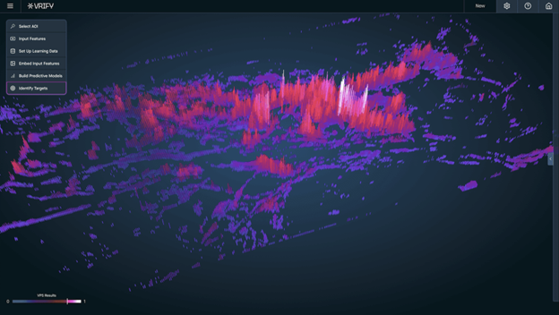
Example of VRIFY’s AI-Assisted Mineral Discovery Platform, DORA
About VRIFY
VRIFY transforms mineral exploration using DORA, the world’s first AI-Assisted Mineral Discovery Platform that helps mining companies more effectively predict mineral deposits, assess exploration potential, communicate project value to investors, and secure investment. With nearly 200 companies across 70 countries partnering with VRIFY, including 26 early-adopter clients using DORA, they set the standard for analyzing and presenting exploration data. Their team of over 100 geoscientists, data scientists, developers, and industry professionals combines deep geological expertise with cutting-edge AI to deliver actionable insights and make discoveries.
On September 9, 2025, Nevada Sunrise announced that it has deepened its partnership with VRIFY by leveraging DORA, VRIFY’s AI-Assisted Mineral Discovery Platform, to identify new target areas at Griffon.
VRIFY Target Generation at Griffon
During Q2 2025, VRIFY’s Geoscience AI teams worked closely with Nevada Sunrise in compiling, cleansing and expanding upon decades of available historical exploration data. The historical data created a comprehensive, high-quality dataset. Using DORA, several areas within the Project were identified as having high prospectivity for additional gold mineralization.

Griffon Gold Mine Project, 2025 VRIFY target areas
Nevada Sunrise plans to conduct Soil Gas Hydrocarbon and conventional soil surveys and perform ground geophysical surveys over the new target areas early in the fall of 2025 to validate these findings and define future drill targets for the Project. The 2025 work will initially focus on an area southwest of the Hammer Ridge pit that was identified as gold-bearing by Alta but was never mined due to Alta’s untimely bankruptcy in 1999. Once a geochemical and geophysical signature of the unmined “Anvil Zone” is established, the Company will seek to compare those signatures to the new targets developed by the VRIFY software.
Griffon Permitting Update
In late July 2025, Nevada Sunrise submitted a Notice of Intent (“NOI”) to the United States Forest Service (the “USFS”) to advise the USFS of its initial surface exploration plans at Griffon. The NOI contained details of a proposed SGH soil sampling survey, an induced polarization (“IP”) survey and a controlled source audio frequency magnetotellurics (“CSAMT”) survey that the Company plans to carry out on the newly-identified target areas within the Project. On August 11, 2025, the USFS responded positively to the Company’s exploration proposal and plans are underway to perform the aforementioned exploration work in the fall of 2025 before inclement weather begins in the region.
Details of the Griffon Mining Lease Purchase Agreement Terms
Nevada Sunrise has entered into a mining lease for Griffon (the “Lease”), which began its term upon execution of the Agreement and remains in effect at the Company’s option until February 13, 2032. The Company retains the right to purchase a 100% interest in Griffon, subject to a 2.0% net smelter returns royalty (“NSR”) with certain buydown provisions, in consideration for the cash payments to the vendors and minimum exploration expenditures as described in the table below (all dollar amounts listed are in US dollars):
Schedule of Cash Payments and Exploration Expenditures
| Payment Due Dates | Cash Payments | Minimum Exploration Expenditures |
|---|---|---|
| Feb. 13, 2025 | $25,000 (paid) | $150,000 |
| Feb. 13, 2026 | $25,000 | $250,000 |
| Feb. 13, 2027 | $25,000 | $400,000 |
| Feb. 13, 2028 | $25,000 | $400,000 |
| Feb. 13, 2029 | $25,000 | $400,000 |
| Feb. 13, 2030 | $25,000 | $400,000 |
| Feb. 13, 2031 | $25,000 | $400,000 |
Nevada Sunrise retains the right to accelerate the timing of cash payments to the vendors at its discretion. The vendors have granted the exclusive and irrevocable right and option for the Company to purchase 100% of Griffon, subject to the 2.0% NSR, at any time during the term of the Lease by paying an amount equal to the aggregate value of any remaining cash payments plus the amount of the greater value of (i) $750,000 and (ii) 285 ounces of .999 gold.
At any time during the term of the Lease if minimum annual exploration expenditures are exceeded in any year, which include property maintenance costs and any other costs related to exploration and development of the Project, the excess expenditures will be credited to a succeeding year.
Qualified Person
The scientific and technical information above has been reviewed and approved by Robert M. Allender, Jr., CPG, RG, SME, who is an independent consultant to Nevada Sunrise and a Qualified Person as defined in National Instrument 43-101 – Standards of Disclosure for Mineral Projects. Mr. Allender has examined information regarding the historical exploration at Griffon, which includes his review of the historical sampling, analytical and procedures underlying the information and opinions contained herein.
Management cautions that historical results were collected and reported by operators unrelated to Nevada Sunrise and have not been verified nor confirmed by its Qualified Person; however, the historical results create a scientific basis for ongoing work in the Griffon property. True widths of the historical mineralized intervals reported in this news release are unknown at this time. Management further cautions that historical results, discoveries and published resource estimates on adjacent or nearby mineral properties, whether in stated current resource estimates or historical resource estimates, are not necessarily indicative of the results that may be achieved on the Griffon property.